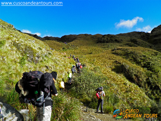
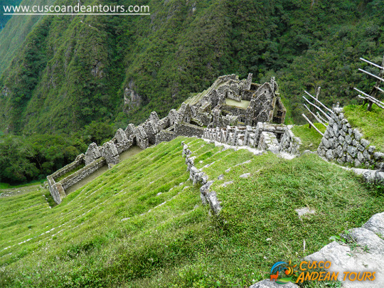
One of the main attractions along the route is the ancient network of settlements built in granite rock by the Incas such as Wiñay Wayna and Phuyupatamarca immersed in an overwhelming natural setting. Hundreds of varieties of orchids, multi-colored birds, and dreamy landscapes provide the ideal setting for a route that the walker should walk at least once.

Description of the Inca Trail to Machu Picchu route
Based on the traditional 4-day / 3-night Inca TrailThe total distance of the road is approximately 39.6 km. And begins at km 82 in the place called Pisqacucho. To start the journey you should cross a bridge, then head to the left side through an eucalyptus orchard and start the day calmly.
Almost immediately you will find the archaeological complexes of Q’ente, Pulpituyoc, Kusichaca and Patallaca. From that last point the path will continue along the left bank of the Kusichaca river in the area with the same name where you will not only see the bridge but also find tombs, aqueducts, terraced paths and a canyon. You will continue until you reach the small town of Wayllabamba and Inca aqueducts. It takes around 4 hours to reach 9 km from this point. One will camp there the first night.
The second day is more difficult, because the walker will have to climb up to 4,200 meters, crossing the Warmiwañusqa pass, the first and the highest. If you suffer from "soroche" (altitude sickness) it is best not to stop or descend quickly to the Pakaymayu river valley, where you can camp. This place is 7 km away and it is approximately 8 hours away.
The third day is the longest but the most interesting. You will be ready to visit the most impressive complexes such as Runkuraqay, the second pass at 3,800 meters above sea level, its complex with yellowed niches that perhaps were a small place to rest, guard posts and places for worship after crossing the second step you descend to Yanacocha (The Black Lagoon) and then climb a path with stone steps until you reach another group of buildings which attract the attention of visitors. This point is called Sayaqmarka a pre-Hispanic complex with narrow streets, buildings erected on different levels; sanctuaries, patios, canals and an exterior protective wall. At the top of the buttresses one can see many buildings which lead one to suppose that it was once a temple and an astronomical observatory, which had a permanent water supply and excellent food stores.
Sayaqmarka is a place full of mystery and charm. The approximate distance to Runkuraqay is 5 km. Which takes 2 hours. This complex extends 3,600 meters above sea level. There is a great trail and tunnel through this complex. We recommend camping near the ruins of Phuyupatamarca or 3 km further on in the Wiñay Wayna visitor center, where one can buy food and drinks or use hygienic services. The ruins of Phuyupatamarca are better preserved than we have seen before now.
On the fourth day, which will start around 5:00 a.m., the walker arrives in Machupicchu around 7:00 a.m. after 8 km of walking through the jungle. Follow the indicated route and drink some water at the Wiñay Wayna Visitor Center. The trail is clearly marked but try to avoid getting too close to the edge of the cliff.
Camping in Inti punku is prohibited. You will leave your equipment at the control gate and enjoy the most important monument in this part of the continent. You will have time to visit Machupicchu until noon. Check the train schedule to return to Cusco.
If you plan to stay in the town of Machupicchu (also called “Aguas Calientes”. The distance from the station to the ruined bridge to Machupicchu is 2 km. This takes about 20 minutes down a narrow path, which runs parallel to the line. iron.

Climate and environment
The climate is relatively mild throughout the year, with heavy rains from November to March, dry and hot weather from April to October, which is a recommended time to visit.The minimum annual temperature ranges from 8 ° to 11.2 ° C. In the months of June, July and August the temperature can often drop below freezing.
The maximum annual temperature varies from 20.4 ° to 26.6 °. The terrain is quite uneven, with several ravines and streams fed by glaciers that eventually pour into the Urubamba River, which crosses the area forming a deep valley that runs through the granite base of Vilcabamba for more than 40 km through a variety of ecosystems.
Landscape of the area
The surroundings are impressive and the balance struck between nature and Inca architecture is astonishing.The Vilcabamba mountains have wide and high peaks that reach up to 6,000 meters as well as Salkantay and Humantay among others.
The mix of mountains, jungles and valleys create a fantastic world where sunrise and sunset are shrouded in mystery.
Wildlife that exists in the route
It is abundant and varied. The existence of endangered species such as the spectacled bear (Tremarctos omatus), the Andean Cock of the Rocks (Rupicola peruviana), the dwarf deer (Pudu mephistopheles), was one of the reasons for the Peruvian government to decide to declare it a Conservation Unit.The park includes species such as the cougar, the Andean fox, the river otter, Taruka (Huemul deer), wild cat, ferret, etc. There are birds in Machupicchu such as the Mountain Caracara, hummingbirds, torrent duck, parrots, wild turkey and several small birds with colorful plumages.
There are also reptiles such as the jergón and the coral micrurus snake (lethal for its poison), lizards, toads and numerous fauna of the jungle and the Andes that inhabit the sanctuary. This abundant wildlife makes the Machupicchu sanctuary ideal for tourists and researchers who want to watch or study animals.
Flora to the area
The long natural areas are filled with a variety of forest species, which vary according to habitat. The forest vegetation is represented by trees such as: cedar, romerillo or intimpa, laurel, etc. There are also species such as Ocotea, Pedocarpus, Guarea, Weinmania, Clusia, Cedropia, Cinchena, Eritrina or Pisonay, and oak among others. Decorative plants have made the sanctuary famous. Experts have identified more than 90 species of orchids and various species of begonias and the puya cactus. Most of the area is covered by grasses, shrubs, tree plants. The variety of conditions have created an ideal environment for the growth of diverse plants that goes from the thick jungle like the forest clouds to the highest parts of the mountains.INFORMATION OF INCA TRAIL TO MACHU PICCHU


0 comentarios:
Publicar un comentario