MACHU PICCHU TOUR
PHYSICAL CHARACTERISTICS OF MACHU PICCHU
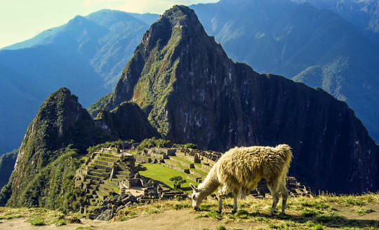
The site is located in the zone of the high forest, and includes part of a mountain mass of great dissection of the high plateau of the Andes, that rises abruptly from the valley of the Urubamba river. The area around the ruins of Machu Picchu is made up of many exposed pinnacles of rock to support the thin soils, although in the area there are also sites with complex soil systems for soil conservation, known as terraces or Inca terraces. . The Urubamba basin is a zone of alluvium, almost continuous, of agricultural land for farming and grazing. Geologically the area is very complex, it is a combination of Cretaceous-Tertiary marine sedimentary rocks and intrusive volcanic material, such as lavas and granites. The sedimentary deposits are Ordovician schists, shales and quartzites. Rivers and streams feed the main system of the Urubamba River Valley, as well as a series of small valleys in the north such as Quillabamba (MAA, 1986).
CLIMATE OF MACHU PICCHU
The average annual temperature varies between 16 ° C and the annual rainfall ranges between 1500 mm and 3000 mm at low altitudes. At 2,500 m altitude the average temperature is 10.2 ° C, and the annual rainfall is 2170 mm. The dry weather season lasts from May to September and the wet weather season from October to April.
VEGETATION OF MACHU PICCHU
The site has been influenced by man for many centuries, leading to a combination of artificial habitats, páramo grasslands, Polylepis thickets, partially degraded virgin forests and old farmlands that have once again become forests or scrub. At lower altitudes, forests predominate, their extent depends on human interference, especially during the Inca period. The vegetation rises from the subtropical dry forest along the river valleys to the very humid low montane forest. The trees represented in the most dense forest in danger of extinction locally include the mahogany Swietenia macrophylla and species of the following genera: cedar, Podocarpus (the only conifer in Peru), Lauraceae Ocotea, Cunoniaceae Weinmannia, Nectandra and Cecropia. A number of tree ferns are present, including Cyathea sp. and also the palms like Geromoina sp. Guasca and SP Riupala. (MAA, 1981). Junks Phragmites sp., Willows and alders are produced around rivers and streams, grasslands open at the same time, bushes and scattered thickets of Polylepis sp. and bamboo are found near the ruins (Parker et al, 1982). The high altitude subalpine paramo includes many grasses, Festuca sp., Stipa sp. and Puya sp. as p. raimondii (I). The ridges of the mountains are characterized by Gaudua bamboo sp. (Parker et al., 1982).
FAUNA DE MACHU PICCHU
The park was established to protect the landscape of the famous archaeological site of Machu Picchu, founded by the Inca culture. It is thought that it was a real Inca residence and perhaps it was the center for collecting coca from the surrounding plantations. The site was finally ruined, it was covered by the invading forest and 'lost by science' until its discovery in 1911. There are also remains of the Inca Trail in the area, and local legends, including that of the spectacled bear. , which is believed to serve as a messenger between spirits of high elevations and those of the jungle (Anon, 1981).
Birds of Machu Picchu - Photo Gallery (5)
Picaflores of Machu Picchu - Photo Gallery (8)
CULTURAL HERITAGE
The park was established to protect the landscape of the famous archaeological site of Machu Picchu, founded by the Inca culture. It is thought that it was a real Inca residence and perhaps it was the center for collecting coca from the surrounding plantations. The site was finally hidden, was covered by the forest and was 'lost by science' until its discovery in 1911. There are also remains of the Inca Trail in the area, and the spectacled bear that is believed to serve as a messenger among the spirits of high elevations and those of the jungle (Anon, 1981).
LOCAL HUMAN POPULATION
Much of the park area is settled with many small farming communities and farms, especially on the lower slopes. The original inhabitants were experts in irrigation and built terraces and drainages that extended long distances through irregular terrain. Agriculture (corn and barley) and livestock grazing (llamas, cattle and sheep) are the dominant economic activities and occur in more than 20,000 hectares of the park. The local economy is also supported by tourists who visit the Inca ruins (MAA, 1981, Peyton, 1983). The nearby city of Cusco was the Inca capital and remains an important city with more than 105,000 inhabitants. It is the administrative and commercial center of a considerable part of the Urubamba basin (INRENA, pers., 1995).

Social Profiles


0 comentarios:
Publicar un comentario